![]() I will start with a caveat. I am a owner in a real estate development company and I am not primarily shopping homes for clients, but instead buying properties to develop and build. That being said, you may think I have nothing but critiques for any other real estate company… not true! Dustin and I have been playing with mapping applications in regards to real estate for a long time. This is actually the way I was introduced to RCG.
I will start with a caveat. I am a owner in a real estate development company and I am not primarily shopping homes for clients, but instead buying properties to develop and build. That being said, you may think I have nothing but critiques for any other real estate company… not true! Dustin and I have been playing with mapping applications in regards to real estate for a long time. This is actually the way I was introduced to RCG.
Way back then we (LTD, not Dustin) were attempting to integrate what was not being done… Aerial parcel mapping of real estate listings. Around that time Redfin launched a pretty slick product. As a visitor of Redfin my only complaint was the size of the viewable space. There was no site out there that utilized the whole page like Microsoft’s Virtual Earth. The size and detail of the photos (at least in the PNW) were great and although not that recent at the time, much better than using what else was out there.
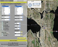
 My biggest gripe with Redfin has been their use of space, most notably the size of their map. In my eyes you could get an idea of the neighborhood, but not a great idea without knowing the area already. Virtual Earth’s full size maps on the other hand were and are great. NWMLS made us change the name of the map because of the words MLS in the URL. MLSMAPSONLINE (image to the right) used the full size maps and parcel data much like Redfin, except we choose to use an opaque layer over a part of the map to maximize the user experience. We stopped working on that product when Zillow launched and we realized it would take too much $$$$$ to stay in the game.
Anyway as I said I am a guilty of using Redfin. When John L Scott did a great job when they launched their new site using Virtual Earth. A great job, but were still missing many of the features that made Redfin great. Redfin was much faster than the NWMLS for a simple search and easy to drag the map to increase the prospective area. I still never understood why they used such a small area for the map, but then again, they were my competition so I wasn’t that worried about the problem.
Then I heard they launched a new version using Virtual Earth. I was so excited when I caught word I quickly ran to my mouse and was ready for the thrill, but I was quickly let down when I saw they kept the same map size and page orientation.
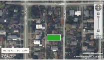
Here is the image from Redfin

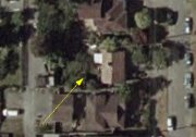
Here is the image from Shackprices

It would be great if when using Redfin you could see how the house sat on the lot, what size is the front yard, where the driveway is, in this pick the massive amount of trees in the front and rear yards, etc. I am sure the parcel box will be changed right away, but I am surprised about the map size and location of the content. There is plenty of room on the monitor, so I am confused. MLSMapsOnline used the vertical orientation, so I know it can be done.
In then end, this blog is not about a critique, but instead a nudge nudge.
